Liens externes
  • Directories
  • Faculties
  • Libraries
  • Campus maps
  • Sites A to Z
  • My UdeM
    • Mon portail UdeM
    • My email
    • StudiUM
Dessin du pavillon Roger Gaudry/Sketch of Roger Gaudry Building
University Home pageUniversity Home pageUniversity Home page
Papyrus : Institutional Repository
Papyrus
Institutional Repository
Papyrus
    • français
    • English
  • English 
    • français
    • English
  • Login
  • English 
    • français
    • English
  • Login
View Item 
  •   Home
  • Faculté de l'aménagement
  • Faculté de l'aménagement – Travaux et publications
  • View Item
  •   Home
  • Faculté de l'aménagement
  • Faculté de l'aménagement – Travaux et publications
  • View Item
JavaScript is disabled for your browser. Some features of this site may not work without it.

My Account

To submit an item or subscribe to email alerts.
Login
New user?

Browse

All of PapyrusCommunities and CollectionsTitlesIssue DatesAuthorsAdvisorsSubjectsDisciplinesAffiliationTitles indexThis CollectionTitlesIssue DatesAuthorsAdvisorsSubjectsDisciplinesAffiliationTitles index

Statistics

View Usage Statistics
Show metadata
Permalink: http://hdl.handle.net/1866/16312

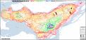
Carte des creux et crêtes et de l'altimétrie de l’île de Montréal

Map of the island of Montreal's thalwegs, crest lines, and altimetry

Map
Thumbnail
Creux-Cretes-Altimetrie---Thalwegs-CrestLines-Altimetry-1-20000.pdf (19.80Mb)
2016-11-29
Author(s)
Mahaut, Valérie
Affiliation
  • Université de Montréal. Faculté de l'aménagement. École d'architecture
Keywords
  • Montréal
  • cartographie
  • cours d'eau
  • ruisseaux
  • creux
  • crêtes
  • bassins versants
  • talweg
  • carte historique
  • hydrographie
  • topographie
  • relief
  • altimétrie
  • mapping
  • cartography
  • watercourses
  • stream
  • ridge line
  • crest line
  • watershed
  • thalweg
  • historical map
  • hydrography
  • topography
  • altimetry
Abstract(s)
Carte de l’île de Montréal présentant les creux actuels les plus proches des lits des anciens cours d’eau mentionnés sur les cartes historiques, les limites des bassins versants de chaque ancien cours d’eau, les courbes de niveau tous les mètres et la grille de référence du SCoPQ.
 
Map of the island of Montreal showing the current thalwegs closest to the trajectories of former watercourses as they appear on historical maps, the boundaries of the watersheds of each former watercourse, contour lines every metre, and the QPCS's reference grid.
Note(s)
Pdf en couleur au format 252 x 119 cm, échelle 1:20.000
 
Colour pdf in format 252 x 119 cm, scale 1:20.000
 
Ce document fait partie de l'étude "Cartographie des anciens cours d’eau, lignes de creux et des bassins versants de l'île de Montréal - Cartography of the island of Montreal's former watercourses, thalwegs, and watersheds". La documentation du projet (Guide d'utilisation et autres documents connexes) est disponible ici: http://hdl.handle.net/1866/16314
 
This document is produced as a part of the study "Cartographie des anciens cours d’eau, lignes de creux et des bassins versants de l'île de Montréal - Cartography of the island of Montreal's former watercourses, thalwegs, and watersheds". Detailed project documentation (User's guide along with other relevant material) is available here: http://hdl.handle.net/1866/16314
Collections
  • Faculté de l'aménagement – Travaux et publications [121]

DSpace software [version 5.8 XMLUI], copyright © 2002-2015  DuraSpace
Contact Us | Send Feedback
Certificat SSL / SSL Certificate
les bibliothéques/UdeM
  • Emergency
  • Private life
  • Careers
  • My email
  • StudiUM
  • iTunes U
  • Contact us
  • Facebook
  • YouTube
  • Twitter
  • University RSS